


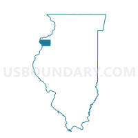
NEW BOSTON 2 Voting District, Mercer County, Illinois
About
Outline

Summary
| Unique Area Identifier | 573586 |
| Name | NEW BOSTON 2 Voting District |
| County | Mercer County |
| State | Illinois |
| Area (square miles) | 26.52 |
| Land Area (square miles) | 26.37 |
| Water Area (square miles) | 0.15 |
| % of Land Area | 99.43 |
| % of Water Area | 0.57 |
| Latitude of the Internal Point | 41.19395440 |
| Longtitude of the Internal Point | -90.94356860 |
Maps


Graphs
Select a template below for downloading or customizing gragh for NEW BOSTON 2 Voting District, Mercer County, Illinois


Neighbors
Neighoring Voting District (by Name) Neighboring Voting District on the Map
- ABINGTON Voting District, Mercer County, IL
- DUNCAN Voting District, Mercer County, IL
- ELIOT TWP Voting District, Louisa County, IA
- ELIZA Voting District, Mercer County, IL
- KEITHSBURG 2 Voting District, Mercer County, IL
- MILLERSBURG Voting District, Mercer County, IL
- NEW BOSTON 1 Voting District, Mercer County, IL
Top 10 Neighboring County Subdivision (by Population) Neighboring County Subdivision on the Map
- New Boston township, Mercer County, IL (1,204)
- Millersburg township, Mercer County, IL (755)
- Keithsburg township, Mercer County, IL (687)
- Eliza township, Mercer County, IL (419)
- Abington township, Mercer County, IL (392)
- Eliot township, Louisa County, IA (334)
- Duncan township, Mercer County, IL (272)
Top 10 Neighboring Place (by Population) Neighboring Place on the Map
Top 10 Neighboring Unified School District (by Population) Neighboring Unified School District on the Map
Top 10 Neighboring State Legislative District Lower Chamber (by Population) Neighboring State Legislative District Lower Chamber on the Map
- State House District 72, IL (101,862)
- State House District 94, IL (100,005)
- State House District 87, IA (27,761)
Top 10 Neighboring State Legislative District Upper Chamber (by Population) Neighboring State Legislative District Upper Chamber on the Map
- State Senate District 36, IL (206,729)
- State Senate District 47, IL (203,948)
- State Senate District 44, IA (55,643)